EGERTON NEIGHBOURHOOD PLAN
Egerton - Site Assessment
Egerton - Site Assessment

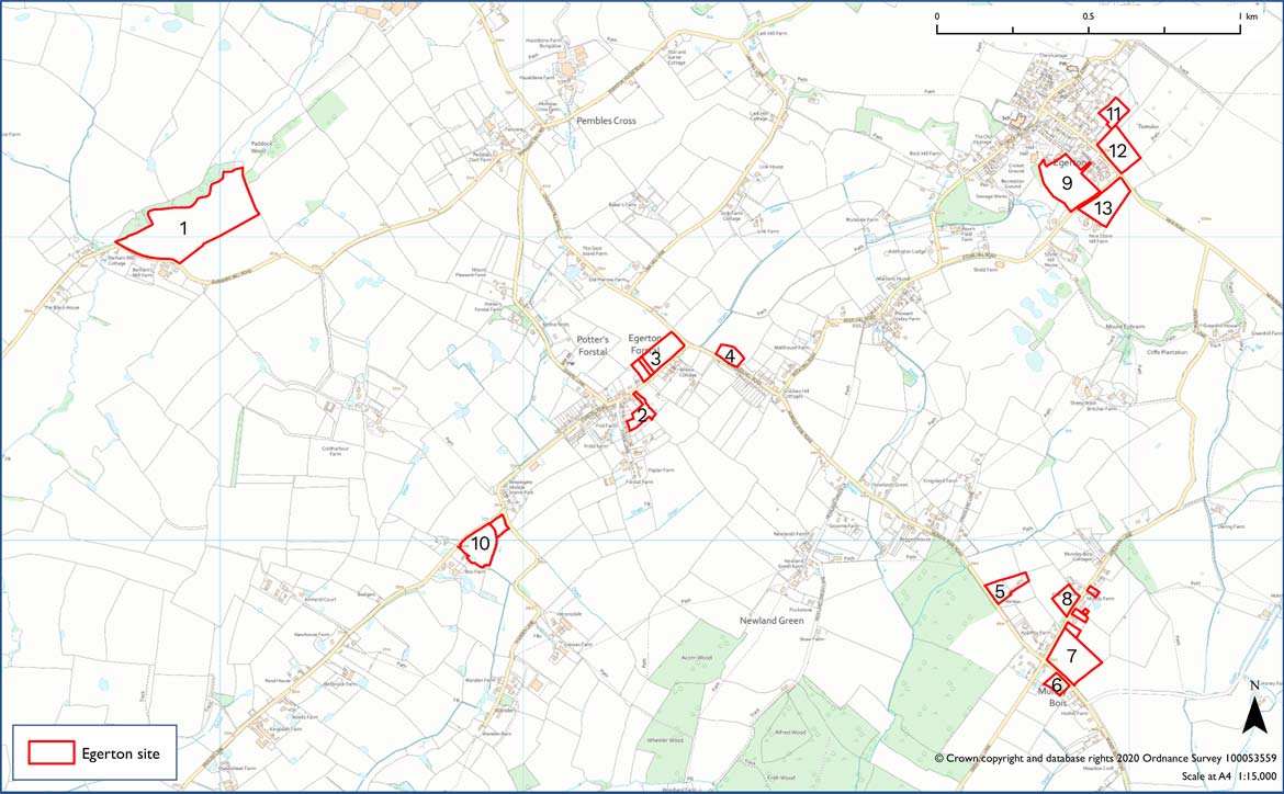
Map of Egerton - all sites. Click to download a higher resolution copy here Egerton - All Sites [pdf]
Please click the links to view each site in detail
Site Assessment
Site 1: HARDENS FIELD, BARHAMS MILL ROAD
Proposed business development (No proposed housing)
- Maintains green gaps to preserve distinct settlement character
- Business & economic potential but on a greenfield site
- Could create a visual intrusion on an open rural landscape & vista in the open countryside ad well away from the village confines
- Not sensitive to current settlement pattern
- Likely adverse impact on neighbouring residential property
- Has potential to create adverse traffic impact on very narrow road
- Potential adverse environmental impact in a remote rural setting, e.g. light pollution, loss of natural habitat
Site 4: GALE FIELD, CROCKENHILL ROAD
Type of housing proposed: 2 & 3 Bed Semi Detached Houses - plus 1 & 2 Bed Maisonettes No. of houses: Up to 10 houses & 2-3 maisonettes
- Maintains green gaps to preserve distinct settlement character
- Provides wholly for affordable local needs housing
- Maintains key views and vistas as selected by villagers
- Is sensitive to current settlement pattern; but would create ribbon development
- Has some adverse impact on neighbouring properties, would not be over-bearing
- Has some impact on local traffic, but could reduce other street parking and there is adjacent footpath access to village centre with scope to improve it
- Has minimum environmental impact – it provides recreational & amenity facilities, preserves natural features and would add more trees
Site 3: FORSTAL ROAD/CROCKENHILL ROAD
Type of housing proposed: 2 & 3 Bed Detached and Semi-Detached Bungalows No. of houses: 2 Detached, 4 Semi-Detached, open market sale
- No green gap between the site and existing residential property
- Possible scope for some starter or self-build homes along with open market housing
- Does not affect key views and vistas as selected by villagers
- It would create a long ribbon of development
- Has an impact on residential properties opposite
- Has adverse impact on roads or traffic congestion
- Has minor environmental impact, with scope for recreation/amenity space
Site 6: ORCHARD COTTAGE LAND, MUNDAY BOIS ROAD
Type of housing proposed: 3 - Bed detached houses Number of houses: 2 for open market sale
- Maintains green gaps to preserve distinct settlement character
- Does not provide affordable/local needs housing
- Maintains key views and vistas as selected by villagers
- Is sensitive to current settlement pattern & Parish Design Statement
- Has no adverse effect on neighbouring properties, will not be over-bearing
- Has minimum impact on roads or traffic congestion
- Has minimum environmental impact; however the small number of homes is outside scope of this Plan
Site 9: HARMERS WAY – NORTH FIELD
Type of housing proposed: 2 Detached Houses plus 20 mixed detached, semideatched & terraced houses. No. of houses proposed: 22, including about 9 affordable/local needs (40% as advised by ABC)
- Does not produce a green gap between proposed site and the existing developed site
- Provides some affordable/local needs housing with open market housing
- Adverse impact on key views as selected by villagers; creates disturbed view down from the Greensand Way and up from the Weald
- Proposal is not sensitive to current settlement pattern nor in line with the Parish Design Statement although benefits from being close to village centre and amenities
- Density of development would be impactful and over-bearing on neighbouring properties, including within the proposal itself
- Would have a significant impact on road access and traffic to neighbours and locality
- Has some adverse environmental impact in view of density of development added to the existing development and on the environmentally sensitive Greensand ridge